Technologies

Total Surveys Station

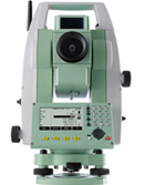
The total station is mounted on a tripod and leveled before use. The other part of a total station, the electronic distance measuring device, measures the distance from the instrument to its target. The total station allows measurement of this type to be taken by simply targeting someone as they move down the avalanche chute (assuming it's safe to do so). The total station provides a quicker solution to this measurement by allowing a light beam to measure the distance instead of a tape measure.

Leveling Station

Surveyor's level, instrument used in surveying to measure the height of distant points in relation to a bench mark (a point for which the height above sea level is accurately known). It consists of a telescope fitted with a spirit level and, generally, mounted on a tripod. It is used in conjunction with a graduated rod placed at the point to be measured and sighted through the telescope.

GPS

The Global Positioning System (GPS) is a satellite-based navigation system made up of a network of 24 satellites. GPS satellites circle the earth twice a day in a very precise orbit and transmit signal information to earth. GPS receivers take this information and use triangulation to calculate the user's exact location. Essentially, the GPS receiver compares the time a signal was transmitted by a satellite with the time it was received. The time difference tells the GPS receiver how far away the satellite is. Now, with distance measurements from a few more satellites, the receiver can determine the user's position and display it on the unit's electronic map.

Satelite Imagery

Satellite imagery consists of photographs of Earth or other planets made by means of artificial satellites.. The first images from space were taken on sub-orbital flights. The first satellite (orbital) photographs of Earth were made on August 14, 1959 by the U.S. All satellite images produced by NASA are published by Earth Observatory and are freely available to the public. Several other countries have satellite imaging programs, and a collaborative European effort launched the ERS and Envisat satellites carrying various sensors.

Radiology of building

Radiology is a leading provider of high quality imaging services in the metropolitan Lansing and other outstate

Under ground services sensor

Whether you want to avoid underground service pipes and power cables or dig them up, these locators trace them quickly, accurately and safely.

Electronic Distance Meter

The total station is an electronic theodolite (transit) integrated with an electronic distance meter (EDM) to read slope distances from the instrument to a particular. Modern EDM equipment contains hard-wired algorithms for reducing the slope distance to its horizontal and vertical equivalent. For most engineering surveys, Total stations combined with electronic data loggers are now virtually standard equipment on site. Basic theodolites can be transformed into total stations by add-on, top-mounted EDM modules.

Quick Enquiry

PR & News

Our Clients